

In 1948, the Massachusetts Department of Public Works (MassDPW), led by commissioner William F. Callahan, proposed a controlled-access, multi-lane loop route to connect downtown Boston with other radial expressways. By serving crosstown traffic, the “Belt Route” was to relieve a large portion of the 15,000 through trips on Boston’s antiquated street network.
Forming a 7.3-mile-loop around the southern, western and northern edge of downtown Boston, the route of the Inner Belt Expressway was described in the Master Highway Plan for the Boston Metropolitan Area as follows:
The selected route begins at the interchange between the Southeast and Southwest expressways near Massachusetts Avenue and Southampton Street, and extends in a westerly direction via Roxbury Crossing to connect with Huntington Avenue, Jamaica Way and Brookline Avenue. From this point, it extends in a northerly direction to cross Beacon Street and Commonwealth Avenue paralleling the Cottage Farm (Boston University) Bridge across the Charles River to connect with the Western Expressway (early I-90 alignment). From this point, the Belt Route passes through Cambridge in a northeasterly direction to Somerville, making an interchange connecting with the Northwest Expressway (unbuilt US 3-MA 2) in the vicinity of Washington Street. From this interchange, it travels in an easterly direction paralleling the Boston and Maine Railroad, crossing its main yards to an elevated interchange just west of City Square, where it connects with the Northeast Expressway (US 1).
Interchanges were to be constructed at the following locations:
- Southeast Expressway (I-93) / Southwest Expressway (unbuilt I-95), Boston
- Washington Street, Boston
- Columbus Avenue, Boston
- Brookline Avenue, Boston
- Worcester Turnpike (MA 9), Brookline
- Beacon Street, Boston
- Commonwealth Avenue, Boston
- Soldiers Field Road, Boston
- Western Expressway (early I-90 alignment), Cambridge
- Massachusetts Avenue (MA 2A), Cambridge
- Northwest Expressway (unbuilt US 3-MA 2), Cambridge
- Northern Artery / Medford Boston, Somerville
- Northeast Expressway (US 1), Somerville
The Inner Belt Expressway was to continue south along the route of the elevated Central Artery, providing connections to downtown Boston and Logan Airport. Note that there was to be no direct connection to the Northern Expressway (I-93), due to its close location between the Northwest and Northeast expressways. (Engineers sought adequate spacing of access points to controlled-access routes.)"
You can get a better idea of the unbuilt portions from this map:
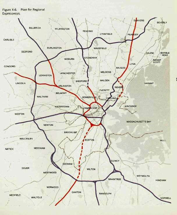
The portions in red were never built or remained as smaller city and state roads and routes. The dotted lines represent major highways planned but never built. You can also see the ring road. Remnants of the unrealized portions of this grand plan still exist.
This interchange at the intersection of I-95 and I-93/Rte 128 in Canton would have been just one waypoint on the way into the city until construction was halted. Now it’s half of a working clovercleaf, while the other half lies fallow, melting back into the forest from which it had been carved fifty years ago.
How would the city’s character have been different had all these roads been built? Would some neighborhoods thus cut off from the downtown have withered or thrived? How would the economy and the rise of the suburb been affected? Would more business have moved to the suburbs or would they have stayed in the city? Would we have been even more of a car culture, a la Southern California, or would the commuter train and subway system have remained? Interesting to speculate.
What’s also interesting speculation is whether the era of such major highways, at least in the densely packed Northeast, are forever part of history, with our major road projects only being envisioned to repair and rebuild what’s in place.
Image Credit
- luberoff-1: BRorson | Copyright by owner. Used under Fair Use doctrine
- highway: Cambridge Historical Society | Copyright by owner. Used under Fair Use doctrine


Well, there wouldn’t be an Orange line. It was rebuilt on the bed of the I-95 extention through town.
Thank goodness this never took place. I-93 and I-90 did enough damage already. Storrow was also a bad idea.
Thank you for linking to bostonroads.com. I’ve been following the Catholic blogosphere for about five years now and am honored to be linked to Bettnet.com.
I-93 and I-90 did enough damage??? I’m sorry but I can’t imagine the nightmare Boston traffic would be if there were no highways into Boston other than Route 1, big mistake imo to not finish the inner belt in some form, it would have unlocked the whole region if done properly, not just boston but also the north and south shore as well as out west towards Worcester….dropped the ball big time and all we have to show for it is a dilapidated mbta system and over congested roads that would be helped out with ohhhhh I don’t know an inner belt???
I actually have a proposal for not the Inner Belt, but I-95 and Route 3 within 128. I-95 would enter 128 and converge with the railway tracks such that the railway would be one long tunnel, with the stations to the side of the freeway. It would diverge at Arborway and follow the entire Emerald Necklace as a controlled access parkway. It would then enter a tunnel under the Fens and emerge onto the Bowker Viaduct (Charlesgate) where it would follow Storrow Drive east in a wrong way concurrency with I-89 (or Route 3). It would then follow Leverett Circle Connector Bridge to the Tobin Bridge. Then it would follow US 1 to 128. When US 1 becomes the Newburyport Turnpike, a setup will be in place where business is accessible by frontage roads. Then it will follow two underground ramps onto 128, where it will leave 128 briefly thereafter and follow I-95 north. As for Future I-89 (US-3), it will enter Boston entirely on current I-93 from the Pilgrim Expressway. Then, it will diverge at Leverett Circle and follow I-95 southwest before following Soldiers Field Road. It will traverse the Eliot Bridge and wind its way northwest on existing surface US 3, with frontage roads. Then it will join the Concord Turnpike to Lexington, where it diverges to follow an abandoned rail line, which it follows to Vine Creek, where it follows Vine Creek to the interchange with 128. See https://sites.google.com/view/the-freewayhub/i-95-in-boston, https://sites.google.com/view/the-freewayhub/i-89-in-boston.